

















China releases new geological map of Moon
The map will expand the scope of future research into Earth’s satellite
-
![]()
Photo source: Alones Creative / iStock
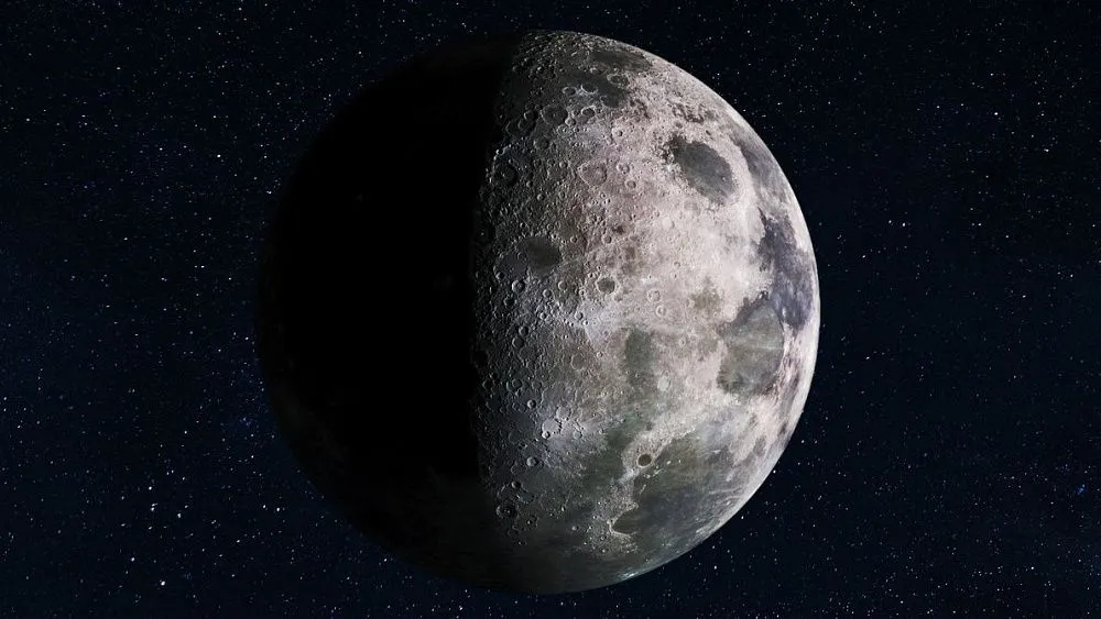
Chinese scientists have completed work on an updated geological map of the entire surface of the Moon at a scale of 1:5,000,000. It incorporates scientific data not included in the 2024 version. This was reported by Xinhua News Agency, a partner of TV BRICS, citing the Institute of Geology at the Chinese Academy of Geological Sciences (IGCAGS).
The new map has been compiled based on research carried out as part of China’s lunar programme. Scientists have also revised the Moon’s geological chronology – updating the age boundaries of the Earth’s satellite’s three oldest geological periods. Soil samples brought back by the Chinese Chang’e-5 mission played a key role in this. Analysis of these samples confirmed that volcanic activity on the Moon continued as recently as around 2 billion years ago.
The new geological map also incorporates, for the first time, the results of the Chang’e-6 mission, which brought back samples from the far side of the Moon. Scientists have presented data on the age of young basaltic rocks in the lunar maria on the far side of the Moon. These findings allow for a more detailed reconstruction of the region’s volcanic history.
"The lunar samples and this map will provide a new starting point for scientific discussions regarding the lunar far side," noted Jin Ming, a research fellow at the institute.
The map reflects new data on lunar minerals. Researchers have established that rocks rich in rare-earth elements and other strategically important resources in the Ocean of Storms, or Oceanus Procellarum, region (the largest lunar mare) are much more widespread and continuous than previously thought.
Furthermore, the map represents a new Chinese cartographic standard. It measures 280 centimetres in length and 120 centimetres in width. It marks more than 13,500 impact craters and 81 impact basins (large depressions on the Moon’s surface). The colour scheme is based on both geological logic and traditional Chinese aesthetics: lighter shades denote younger formations, while darker shades denote older ones.
In future, this standard is set to be used in the creation of geological maps of Mars and asteroids, which will enable China to move away from relying on foreign cartographic systems. As the institute’s director, Yang Zhiming, noted, the standard will form the basis for future geological mapping of planets and will enable the establishment of an independent intellectual property system within the field of Chinese deep-space exploration.
-
![]()
 Technology01.09.26Iranian researchers develop dual-purpose electrodes for renewable energy storage
 -
![]()

 Technology31.08.26Vietnam targets ASEAN’s top three in artificial intelligence by 2030
 -
![]()
 Technology29.08.26China completes world’s largest-diameter underwater shield tunnel
 -
![]()

 Technology29.08.26Kazakhstan develops drought-resistant and salt-tolerant new barley variety
 -
![]() Technology28.08.26Iranian researchers develop light-sensitive hydrogel system for breast cancer treatment
Technology28.08.26Iranian researchers develop light-sensitive hydrogel system for breast cancer treatment -
![]()
 Technology28.08.26BRICS inventions: from AI to clean energy






















-
![Xi Jinping]()
 Xi JinpingPresident of the People’s Republic of China"The foundation of our bilateral relations will only grow stronger, and we will confidently move forward to a better future. […] The striving of nations on our planet for peace, development, cooperation and mutual benefit remains unchanged. The vital mission of the Shanghai Cooperation Organisation is to maintain stability and promote the development of our region"
 -
![Alisher Salomov]() Alisher SalomovAdviser to the Chairman of the National Committee for Ecology and Climate Change of the Republic of Uzbekistan"First and foremost, I would like to highlight the importance of this Central Asia–Russia initiative, because environmental problems know no borders, and only a shared understanding of these problems and the search for joint solutions can deliver positive results"
Alisher SalomovAdviser to the Chairman of the National Committee for Ecology and Climate Change of the Republic of Uzbekistan"First and foremost, I would like to highlight the importance of this Central Asia–Russia initiative, because environmental problems know no borders, and only a shared understanding of these problems and the search for joint solutions can deliver positive results" -
![Joao Paulo Capobianco]() Joao Paulo CapobiancoBrazilian Minister of the Environment and Climate Change"The BRICS countries have a very high level of responsibility because they share an important part of the world's biodiversity, landscapes, populations, food production and water resources. So, we have an opportunity to lead by example. We have our development bank, which can demonstrate and develop new ways of financing programmes. We can reduce the risks for private capital to invest in restoration and efforts to combat desertification"
Joao Paulo CapobiancoBrazilian Minister of the Environment and Climate Change"The BRICS countries have a very high level of responsibility because they share an important part of the world's biodiversity, landscapes, populations, food production and water resources. So, we have an opportunity to lead by example. We have our development bank, which can demonstrate and develop new ways of financing programmes. We can reduce the risks for private capital to invest in restoration and efforts to combat desertification" -
![Dilma Rousseff]() Dilma RousseffPresident of the New Development Bank"India’s BRICS Presidency this year gives special significance to our discussion. NDB stands ready to be a trusted partner in turning commitments on sustainability, clean energy, smart and resilient infrastructure into concrete results on the ground. […] For NDB, mobilising private capital is a strategic imperative. Created by the BRICS founding members, NDB is a bank of the Global South, for the Global South, mandated to mobilise resources for infrastructure and sustainable development"
Dilma RousseffPresident of the New Development Bank"India’s BRICS Presidency this year gives special significance to our discussion. NDB stands ready to be a trusted partner in turning commitments on sustainability, clean energy, smart and resilient infrastructure into concrete results on the ground. […] For NDB, mobilising private capital is a strategic imperative. Created by the BRICS founding members, NDB is a bank of the Global South, for the Global South, mandated to mobilise resources for infrastructure and sustainable development" -
![Sihasak Phuangketkeow]() Sihasak PhuangketkeowDeputy Prime Minister and Minister of Foreign Affairs of Thailand"BRICS can play a very important role in maintaining the free flow of trade and investment. The group can also be a vehicle for all of us to engage and to look at economic opportunities"
Sihasak PhuangketkeowDeputy Prime Minister and Minister of Foreign Affairs of Thailand"BRICS can play a very important role in maintaining the free flow of trade and investment. The group can also be a vehicle for all of us to engage and to look at economic opportunities"